


The Nairobi Rivers Commission has put those who have encroached on riparian land on notice, even as plans to fix the city dam and avert a possible disaster get underway.
Commissioner Mumo Musuva told the Star a technical assessment of the Nairobi City Dam had been completed and was awaiting government appraisal.
“The assessment for the engineering that needs to be done has been completed and is undergoing government appraisals and processes,” he said.
Musuva said the structure of the dam had been compromised to a large extent due to years of neglect.
“Records show that the Nairobi Dam was last maintained in 1998,” he said.
This comes even as scientists warn of a looming El Niño.
Musuva decried the construction of huge apartments near the dam. He said the 30-metre riparian reserve had been encroached on.
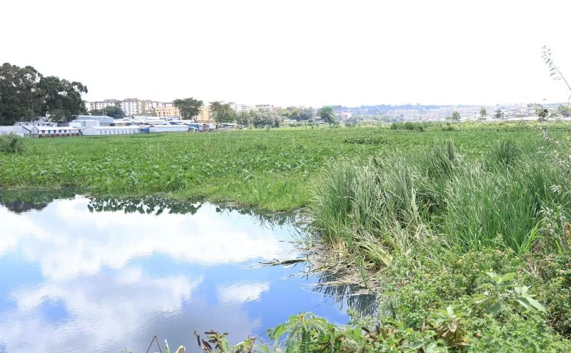
He said the dam also had waste that had been accumulating for years.
“Eighty per cent of the dam is floating waste; this has affected hydrological flows,” Musuva said.
He said the spillway of the dam had also collapsed.
The commissioner said they were exploring ways of rehabilitating the dam, adding that dredging was expensive.
Already, the government has identified some of the high-risk urban centres where the impending El Niño will hit hard.
Nairobi, Mombasa and Kisumu have been identified as high-risk urban centres, where the expected weather conditions could lead to flooding, blocked drainage systems, pressure on infrastructure and disruptions to services.
The government has identified 18 counties that could face the effects of El Niño as Kenya prepares for above-normal rainfall from October this year, with authorities warning the weather conditions could continue into early next year.
The Kenya Meteorological Service Authority says there is an 81 per cent chance the country will experience a strong El Niño event, while the probability that its effects will continue into early next year stands at 97 per cent.
The government has mapped areas that could be affected by several risks linked to the expected weather conditions, including flash floods, landslides, drought, disease outbreaks and damage to infrastructure.
The ongoing plans to rehabilitate the Nairobi Dam by the Water Resources Authority, NRC and Nairobi government follow a renewed push to restore the capital’s environment and avert a potential disaster.
The decision follows growing concern over the dam’s deteriorating condition, with a multi-agency team citing severe pollution and poor waste management as major obstacles to restoration efforts.
Constructed in 1953 for recreation and flood control along the Ngong River, the dam has over the years been degraded by sewage discharge, encroachment and informal settlements.
The Water Resources Authority had initially proposed decommissioning the dam to restore its ecological integrity, but authorities have opted for rehabilitation as part of wider efforts to revive Nairobi’s environment.
In recent months, the dam has emerged as a major safety concern.
During heavy rains, authorities warned of a possible breach, prompting evacuation notices for residents in downstream areas including Kibera, Nyayo Highrise, Dam Estate, Lang’ata, Nairobi West and Madaraka.
The warnings followed rising water levels that threatened to overflow weakened embankments, with the WRA cautioning of imminent flood risks.
At least 33 people were reported to have died in Nairobi during the rains, underscoring the urgency of intervention.
Earlier assessments by Nairobi Governor Johnson Sakaja highlighted structural weaknesses. These included blocked spillways and compromised embankments, raising fears of a potential disaster if corrective measures were not taken.
Proposed interventions include clearing downstream obstructions, conducting geotechnical tests on the embankment and enforcing a 30-metre riparian buffer zone to protect the dam and surrounding communities.
Authorities have maintained that no institution will be exempt from compliance as they move to restore order along Nairobi’s waterways.
The rehabilitation of Nairobi Dam now forms part of a broader multi-agency effort to clean up the Nairobi River Basin, improve environmental management and enhance the city’s resilience to climate-related risks.
Even so, the success of the plan will depend on sustained enforcement, proper waste management and coordination among agencies.
This came as authorities race to prevent a recurrence of the flood threats that have repeatedly placed thousands of residents at risk.
Musuva said the commission had also intensified enforcement against encroachment on riparian land.
The commissioner said the rehabilitation of the dam should be a long-term intervention for it to be economical.
He said a lot was being done to recover riparian areas as well as wayleaves that had been grabbed.
Musuva said the downstream section of the Ngong River below the dam had a lot of land left as riparian reserve but had been grabbed.
“We have been going through the documentation carefully so that when we start recovering, we see how much we can recover what was originally left for the dam.”
Musuva said a multi-agency approach had been embraced.
The National Land Commission is being involved.
Musuva said there were a lot of developments along the Ngong River from Raila Oginga Road all the way to Mombasa Road (Nairobi West) that had encroached on wayleaves and riparian land.
He said the recovery of riparian areas had started near Kiparage and was set to continue in Parklands, Kilimani and Kileleshwa.
“The Parklands operation is the precursor. There will be a lot of work happening in Parklands, going towards Brookside, Arboretum, Kirichwa Ndogo and Kirichwa Kubwa.”
Commissioner Loice Kipkiror echoed Musuva’s sentiments, saying riparian boundaries are determined in accordance with the Physical and Land Use Planning (Riparian Reserve) Regulations, 2021.
“Under these regulations, the riparian reserve is measured from the highest water mark and ranges from a minimum of 10 metres to a maximum of 30 metres, depending on the width of the river,” she said.
Kipkiror said where a river is less than 10 metres wide, the riparian reserve is 10 metres from the highest water mark on either side of the river.
“Where a river is between 10 and 30 metres wide, the riparian reserve is equal to the river’s width. Where a river is more than 30 metres wide, the riparian reserve is fixed at 30 metres from the highest water mark on either side,” she said.
Kipkiror said following the demarcation exercise, notices are issued to affected property owners, advising them to present their title deeds, development approvals and any other relevant documentation to Room 213, Ardhi House, for verification and appropriate redress.
She said the reclamation of riparian land was essential to restore the ecological integrity of the Nairobi Rivers and safeguard the lives and livelihoods of residents.
“Once reclaimed, the riparian corridors will be developed in consultation with local communities to create environmentally sustainable and socially beneficial public spaces,” she said.
Flooding in Nairobi has become a recurring urban challenge driven not only by heavy rainfall, but also by systemic factors such as the city’s topography and hydrology, volcanic soils, which have low permeability and unplanned development in flood-prone areas.
Other factors include inadequate drainage, the loss of wetlands and green spaces, weak enforcement of land-use regulations, fragmented governance, weak institutional management in flood-risk management and limited investment in climate resilience.